Creekside Park is proposed residential subdivision located in southeastern Hillsborough County. The original plans called for a 30-foot deep stormwater retention pond that was located within close proximity to a seepage wetland system. Based on review of the original application, the SWFWMD was requiring the installation of a clay barrier wall along most of the perimeter of the retention pond. The clay barrier wall was to tie in to the clay confining layer beneath the surficial aquifer, at a depth of 30-feet. In response to SWFWMD’s request, HEA was retained by King Engineering, Inc. and Faulkner Engineering, Inc. to evaluate the impacts of the proposed retention pond and optimize design of the barrier wall.
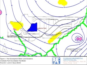 HEA developed a groundwater flow model of the area based upon the SWFWMD’s DWRM II regional model to evaluate the drawdown impacts from the proposed stormwater pond. The model was used to predict the impacts of the proposed pond on the surficial aquifer and nearby wetland system. The barrier wall package of MODFLOW was used to optimize the design of the clay barrier wall. Groundwater flow modeling was conducted using both average annual water levels conditions and seasonal high water level conditions.
 The results of the groundwater flow modeling proved that the barrier wall could be reduced in depth by 20 feet and in length by about 100 feet, and still provide adequate protection to the wetland system from drawdowns due to the proposed stormwater retention pond. As a result of the groundwater flow modeling, the Environmental Resource Permit was successfully obtained without monitoring requirements.
Conducted a Wel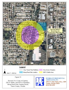 lhead Protection Study of Pasco County water supply well CH-3. Determined the historic range in pumping from the wellfield and determined the 5 and 10 year capture zones of the production wells, using the MODPATH model.
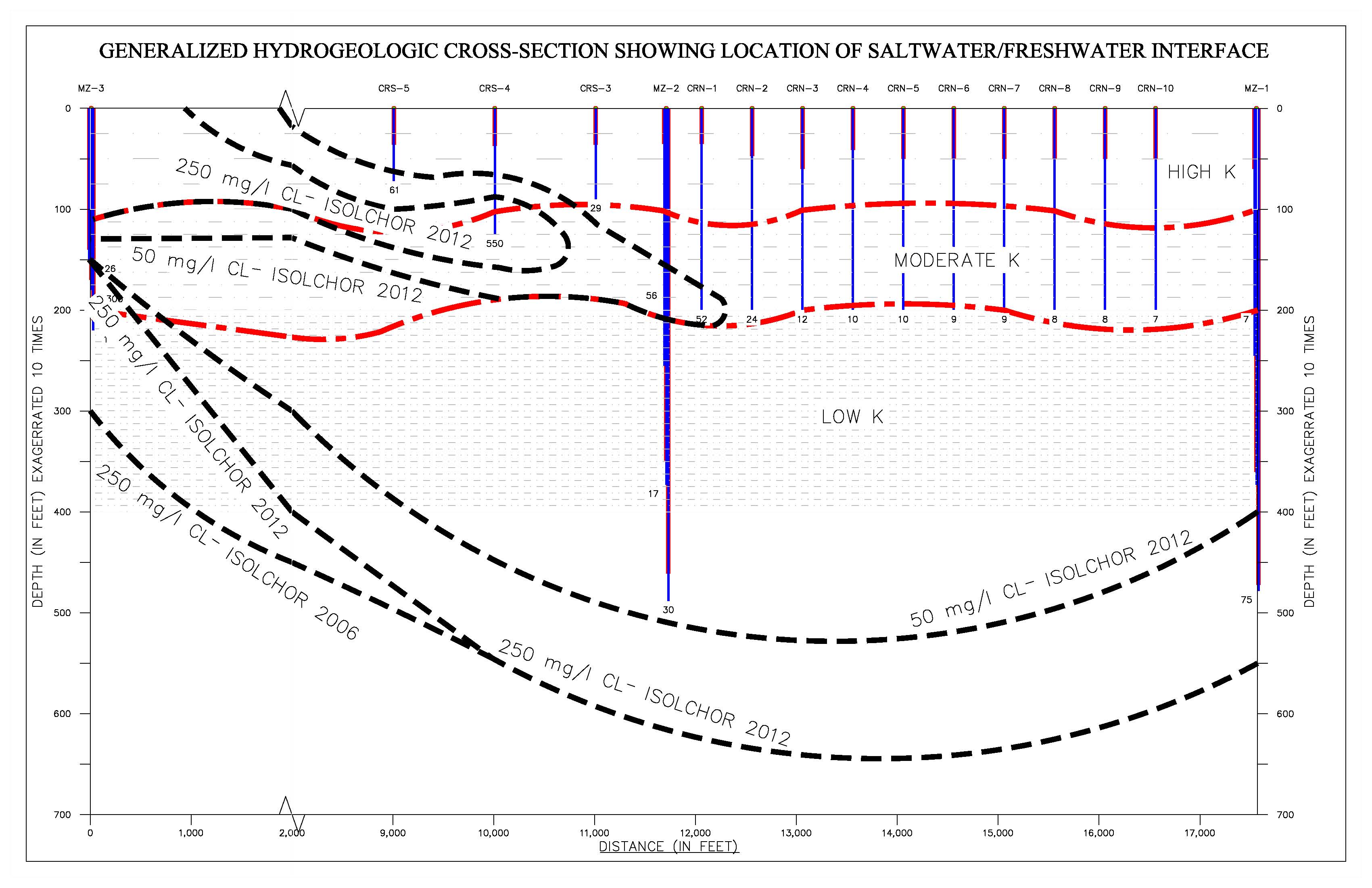
Conducted an evaluation of the Progress Energy water supply wellfields to determine the cause of increasing salinity and other water quality issues. Evaluated geophysical logs, lithologic logs, aquifer pumping tests, and conducted groundwater flow modeling to predict impacts based on current yields and well capacities. The water supply wellfield is configured in a linear direction perpendicular to the coast, and is located within close proximity to the Gulf of Mexico. 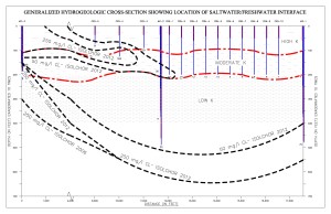
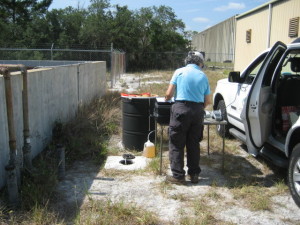
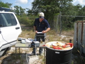 A former tenant at this site recycled and extracted trace metals from automotive catalytic converters. Various acids and alkylines were used in the metal digestion process. As the result of an inspection by the Florida Department of Environmental Protection, a site assessment was conducted. The result of the assessment revealed elevated concentrations of several metals, including arsenic, aluminum, and iron. Natural attenuation is currently ongoing on a quarterly basis at three monitoring well locations.

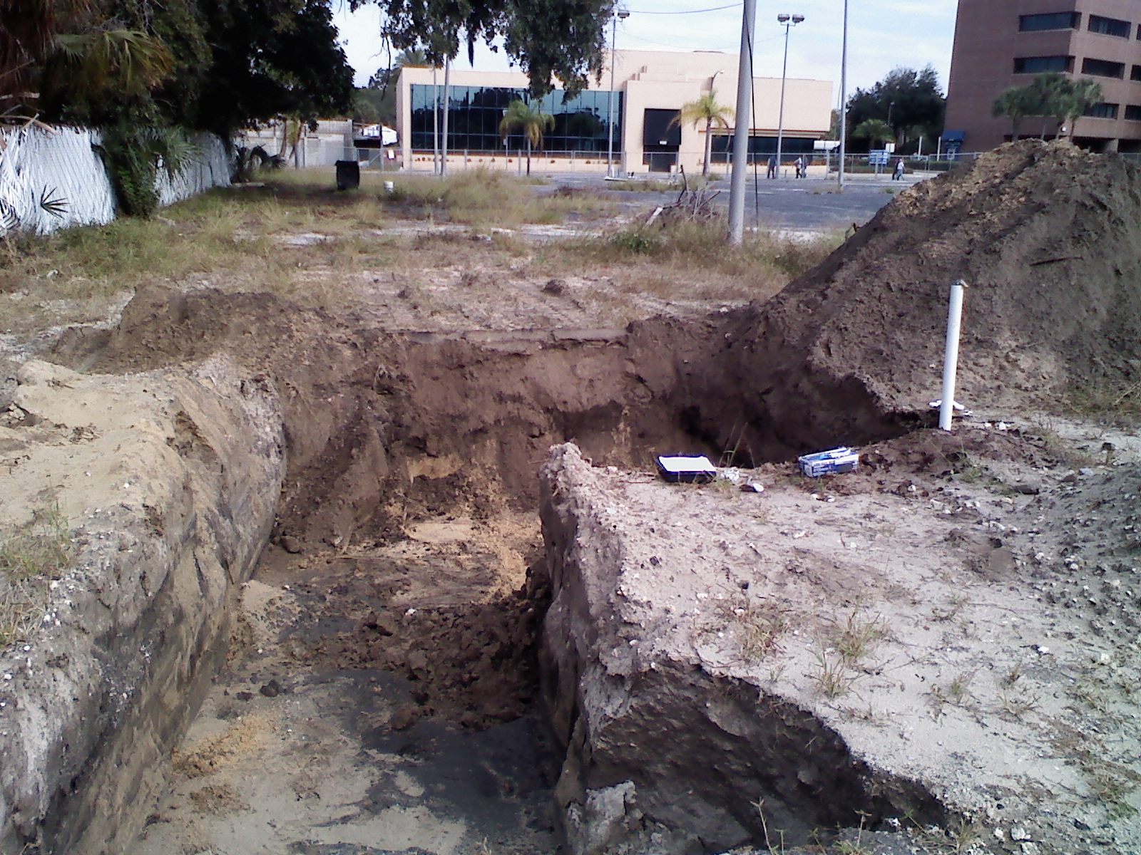
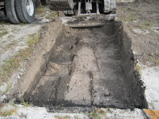
Hydro-Environmental Associates, Inc. conducted a soil and groundwater site assessment and soil remediation of a proposed office and residential complex, located within downtown Clearwater, Florida. The site was a former automotive sales and repair facility. Elevated arsenic concentrations were identified from a specific soil layer underneath a concrete slab that was used for automotive repair and detailing. The horizontal and vertical extent of soil contamination was identified through the results of a series of discreet samples collected from within, around, and below the contamination zone. The contamination zone was carefully defined and delineated during remediation. The contaminated soil was identified as dark-gray fine sand that was used as a fill material underneath the concrete slab. The results of groundwater sampling did not identify leaching of the arsenic into the surficial aquifer underneath the slab.
 The contaminated soil was excavated from the site, temporarily stockpiled awaiting transport, and then transported to a soil recycling facility in Mulberry, Florida for proper disposal.
Hydro-Environmental Associates, Inc. (HEA) conducted a soil and groundwater site assessment and site remediation of the former Stone Buick automotive sales and service facility, located within downtown Clearwater, Florida. HEA initially conducted a Phase I and II Environmental Site Assessment (ESA) which identified the existence of numerous in-ground hydraulic lifts, an oil-water separator, a grease trap, and a septic system. The Phase II ESA included soil and groundwater sampling at each of the hydraulic lift areas, as well as within the oil-water separator, grease trap, and septic tank and leachfield.
The results of groundwater sampling did not detect waste oil group parameters at any of the sample locations above the applicable groundwater cleanup target levels (GCTL)s. However soil contamination was detected in the vicinity of several of the hydraulic lift areas, oil-water separator, and grease trap.
HEA oversaw site remediation activities to remove the 11 in-ground hydraulic lifts, associated hydraulic oil and reservoirs; the oil-water separator; grease trap; septic system; and sand filter bed. Soil screening was conducted by HEA during the site remediation to define and delineate the extent of excessively contaminated soil. Approximately 35 cubic yards of excessively contaminated soil was removed, transported, and thermally incinerated.
Confirmatory soil and groundwater samples were collected at strategic locations upon completion of the site remediation. The results of the confirmatory sampling indicated that the contaminated soil had been successfully remediated, and the results of groundwater sampling indicated that concentrations of waste oil parameters were within the applicable GCTLs.
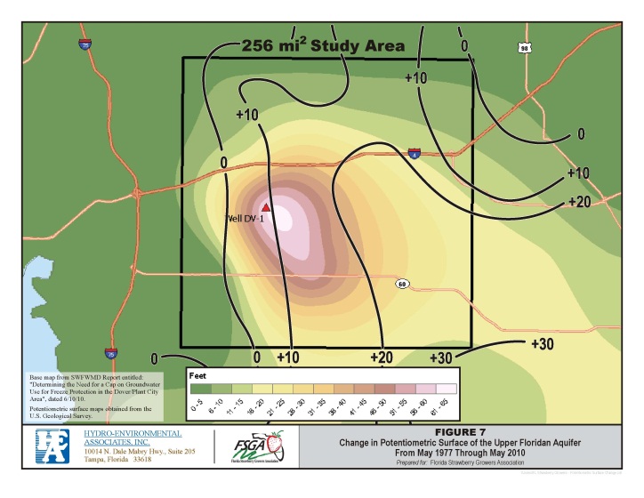
Hydro-Environmental Associates, Inc. (HEA) was selected by the Florida Strawberry Growers Association, Inc., to conduct a regional analysis of the potentiometric surface of the upper Floridan aquifer (UFA) of the Dover/Plant City strawberry growing area. The purpose of the study was to determine long-term trends in water levels of the UFA and identify the main sources of groundwater use in the study area. The Southwest Florida Water Management District recently designated the Dover/Plant City area as a Water Use Caution Area (WUCA) and established a minimum flow and level for the area. The establishment of a WUCA is based on the assumption that there is a long-term decline in the potentiometric surface of the UFA.
HEA evaluated the data from numerous monitoring wells in and around the Dover/Plant City area, and conducted a trend analysis on several wells with long-term daily records. HEA also reviewed historic semi-annual potentiometric surface maps of the SWFWMD area, prepared by the U.S. Geological Survey dating as far back as May 1976.
Based on the results of this study, it was determined that there has actually been an increasing trend in the potentiometric surface of the UFA during the last decade, and water levels have risen up to 30 feet in the area over the last 30 years. The main cause of the water level increases appeared to be the result of an overall shift of the central Florida phosphate industry and associated groundwater withdrawals toward the south and east of the study area.
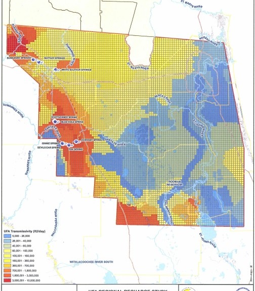
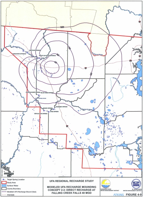
Hydro-Environmental Associates, Inc. (HEA), in association with Atkins North America, Inc. were selected by the Suwannee River Water Management District and St. Johns River Water Management District, to conduct a hydrogeologic assessment of north central Florida. The purpose of the study was to identify and evaluate various concepts to protect, maintain, and restore regional aquifer levels by recharging the Upper Floridan Aquifer (UFA) at strategic locations. The areas of focus include the upper Suwannee River and Santa Fe River watersheds, and the Keystone Heights potentiometric high. Replenishment of the UFA in these areas could benefit surface water features including lakes, springs, and rivers; as well as contributing to the development of a sustainable water supply for the region.
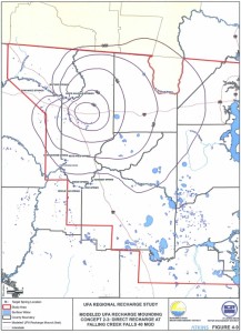
HEA initially identified and evaluated numerous aquifer recharge options within the upper Suwannee River basin, and conducted groundwater flow modeling on several pre-screened sites to further assist in the evaluation process. HEA used the updated U.S. Geological Survey MegaModel to conduct the groundwater flow analysis. The groundwater flow model was used to establish the benefits to the river systems, major springs within the Suwannee River, Ichetucknee, and Santa Fe Rivers, as well as the potentiometric level of the UFA from each of the pre-screened options. HEA modified the existing MegaModel to include each of the proposed recharge options, and simulated the recharge characteristics of three indirect recharge options and three direct recharge options. The direct recharge options mainly consisted of aquifer recharge wells completed within the UFA, and the indirect options included the use of RIBS, sinkholes, and other natural geologic features.
The model was used to predict the benefits of each potential recharge option into selected target springs, including: White Sulphur Springs, Suwannee Springs, Ichetucknee Springs, Blue Springs, Ginnie Springs, Poe Springs, and Hornsby Springs. Many of these springs have shown evidence of declining base flows.
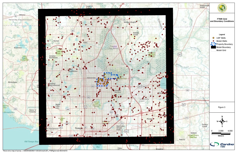
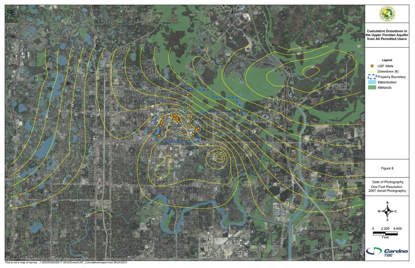
Hydro-Environmental Associates, Inc. (HEA), in association with Cardino/TBE Group, Inc. was selected by the University of South Florida (USF), Tampa, Florida to prepare and submit their updated Water Use Permit. The USF Tampa campus is undergoing major renovations and expansion, including construction of several new athletic fields and on-campus dormatories. The HEA/TBE team determined the average and peak water use quantities for this complex, multi-use application. Water uses include golf course irrigation, athletic field and green area irrigation, industrial cooling tower water use, and municipal water use. Determined current water use using the Southwest Florida Water Management District (SWFWMD) AGMOD program and other methods, and established projected water use through the year 2030 using population demands.

HEA developed a groundwater flow model of the area based upon the SWFWMD’s Districtwide Regulatory Model (DWRM II) regional model using Groundwater Vistas, Version 5. to predict environmental impacts from the water use. The model was used to predict the loss of flow into the Hillsborough River from the pumpage and to insure that the established minimum flows and levels of the river would not be encroached upon by the withdrawals. Prepared a Hydrogeologic Report and impact analysis that accompanied the Water Use Permit.
The Water Use Permit was successfully renewed with a slight increase in permitted quantities while reducing overall drawdown impacts. The drawdown impacts were reduced by performing wellfield optimization techniques through the use of the groundwater flow modeling.

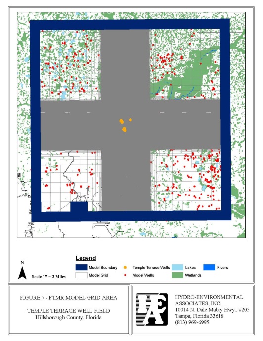
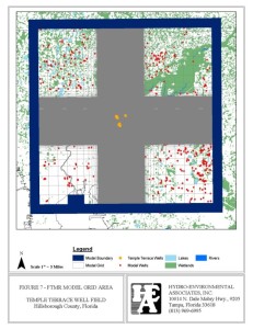 Hydro-Environmental Associates, Inc. (HEA), in association with Cardino/TBE Group, Inc. was selected by the City of Temple Terrace, Florida to prepare and submit their updated Water Use Permit. The City of Temple Terrace wellfield is directly adjacent to the Hillsborough River. The Hillsborough is also the primary source of water for the City of Tampa. The SWFWMD has set minimum flows and levels on
 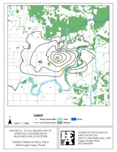 the river, and has issued a moratorium on any new or additional impacts to the river. The HEA/TBE team determined the average and peak water use quantities for this complex, multi-use application. Water uses include golf course irrigation, industrial water use, and municipal water use and the wellfield was recently renovated. Determined current water use using the Southwest Florida Water Management District (SWFWMD) AGMOD program and other methods, and established projected water use through the year 2030 using population demands.
HEA developed a groundwater flow model of the area based upon the SWFWMD’s Districtwide Regulatory Model (DWRM II) regional model using Groundwater Vistas, Version 5. to predict environmental impacts from the water use. The model was used to predict the loss of flow into the Hillsborough River from the pumpage and to insure that the established minimum flows and levels of the river would not be encroached upon by the withdrawals. Prepared a Hydrogeologic Report and impact analysis that accompanied the Water Use Permit.
The Water Use Permit was successfully renewed with a slight increase in permitted quantities while reducing overall drawdown impacts. The drawdown impacts were reduced by performing wellfield optimization techniques through the use of the groundwater flow modeling.
 HEA developed a groundwater flow model of the area based upon the SWFWMD’s DWRM II regional model to evaluate the drawdown impacts from the proposed stormwater pond. The model was used to predict the impacts of the proposed pond on the surficial aquifer and nearby wetland system. The barrier wall package of MODFLOW was used to optimize the design of the clay barrier wall. Groundwater flow modeling was conducted using both average annual water levels conditions and seasonal high water level conditions.
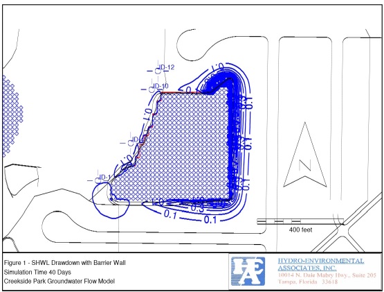 The results of the groundwater flow modeling proved that the barrier wall could be reduced in depth by 20 feet and in length by about 100 feet, and still provide adequate protection to the wetland system from drawdowns due to the proposed stormwater retention pond. As a result of the groundwater flow modeling, the Environmental Resource Permit was successfully obtained without monitoring requirements.